


The Republic of Singapore consists of the main island of Singapore and some 63 offshore islands. It is situated between latitudes 1°09'N and 1°29'N and longitudes 103°36'E and 104°25'E, approximately 137 kilometres north of the Equator.
The main island is about 42 kilometres from east to west and 23 kilometres from north to south. Singapore's total land area, including that of the smaller islands, is 710.2 square kilometres.
Singapore's immediate neighbours are Malaysia (Peninsular Malaysia to the North, Sarawak and Sabah to the East), Brunei Darussalam and Indonesia.
Being very close to the Equator, Singapore's climate is characterised by abundant rainfall, relatively uniform temperature and high humidity throughout the year. The mean daily temperature is 26.8°C.
The population of Singapore was estimated at 4,839,400 in June 2008. Singapore is a multiracial society - the Chinese constitute 76.8% of the population, and the Malays and Indians 13.9% and 7.9% respectively. Other races make up 1.4%.
The official languages in Singapore are Malay, Chinese (Mandarin), Tamil and English. Malay is the national language and English is the language of administration. The Constitution allows every person the right to profess and practise his religion and to propagate it. The main religions in Singapore are Buddhism, Taoism, Islam, Christianity and Hinduism.
Singapore is a republic with a parliamentary system of government. A written constitution provides for the organs of state, namely the executive, the legislature and the judiciary. President S R Nathan is the current Head of State. The current Prime Minister, Lee Hsien Loong, leads the Cabinet in the administration of the Government. The Prime Minister and other Cabinet members are appointed from among the Members of Parliament, of which there are currently 84.
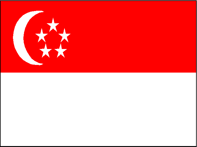
The flag of Singapore consists of two equal horizontal sections, red above white. In the upper left canton is a white crescent moon beside five white stars within a circle. Red symbolises universal brotherhood and equality of man, while white signifies pervading and everlasting purity and virtue. The crescent moon represents a young nation on the ascendant, illuminated by the ideals of democracy, peace, progress, justice and equality as signified by the five stars.
Geography and Climate
Lebanon is a small and beautiful country on the Eastern shore of the Mediterranean Sea. It is located at the meeting point of three continents and, as such, has been the crossroads of many civilizations whose traces may still be seen today. Its coastline is about 225 km (150 miles) in length and is, on average, 45 km (30 miles) wide. The total area of the country amounts to 10,452 square km (4,500 square miles). Along the coast are the five famous cities of Beirut, Byblos, Sidon, Tripoli, and Tyre (see interactive map under Tourism). It is bordered in the north and east by Syria and, in the south, by Palestine.
 Lebanon's beauty is illuminated by its geography (see interactive map under Tourism.) -- its narrow coastal plane and two parallel north/south mountains (the mountains of Lebanon and anti-Lebanon). The fertile Bekaa valley, with its Litani and Orontes Rivers, separates these mountains and nourishes the terrain. Residing majestically over the valley, Qournet Assaouda in the north of Mount Lebanon (altitude 3,083 meters or 10,112 feet) and Jabal al-Sheikh in the south of the anti-Lebanon range (altitude 2,814 meters or 9,230 feet) remain the highest peaks in the country.
This unparalleled natural splendor is enhanced by Lebanon's moderate, Mediterranean climate. Lebanon enjoys about 300 days per year of sunshine. The winter is mild on the coast and snowy in the mountains, while the summer is hot on the coast and mild on the mountains. It is possible during the spring months to ski in the mountains and swim on the coast in the same day!
Government and Politics
Due to its long history, natural beauty, and rich culture, the Republic of Lebanon has always occupied a special place in the world. Beginning with its independence on November 22, 1943, Lebanon has been and continues to be an integral player in the Middle East and throughout the international community. As an Arab country, Lebanon's official language is Arabic; however, English and French are widely spoken. Tolerance and the encouragement of diversity, as well as its strong political culture have confirmed Lebanon's world prominence. Lebanon is a founding member of the League of Arab States (LAS) and the United Nations, and it has played a major role in the drafting of the Universal Declaration of Human Rights.
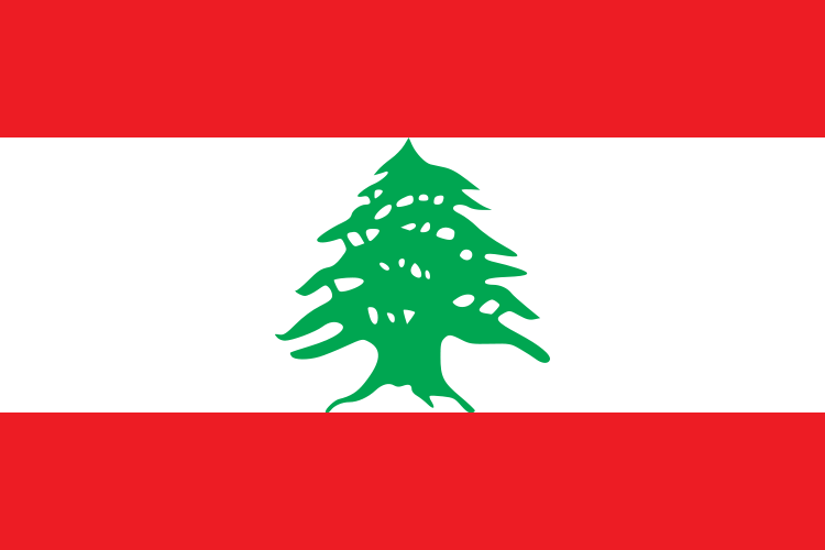
Upon its independence, Lebanon adopted this flag, with the cedar as a symbol of its enduring strength.
As a democratic republic, Lebanon enjoys a parliamentary system of government with a President, a Prime Minister, and a cabinet chosen through an electoral process. The structure of the government is based on the constitutional principle of separation between the executive, the legislative, and the judicial branches.
History
Lebanon has a heritage almost as old as the earliest evidence of mankind. Its geographic position as a crossroads linking the Mediterranean Basin with the great Asian hinterland has conferred on it a cosmopolitan character and a multicultural legacy. Lebanon has an Arab culture colored by Western influences.
At different periods of its history, Lebanon has come under the domination of foreign rulers, including Assyrians, Babylonians, Persians, Greeks, Romans, and Ottomans. Although often conquered, the Lebanese take pride in their rebellions against despotic and repressive rulers. Moreover, despite foreign domination, Lebanon's mountainous terrain has provided it with a certain protective isolation, enabling it to survive with an identity all its own.
Historical BackgroundA Rich, Proud and Diverse Foundation
Today’s Azerbaijani citizens are the heirs to a rich history and culture. Located in the Caucasus, on the western coast of the Caspian Sea, the modern Republic of Azerbaijan occupies the world’s most important strategic crossroads between East and West. A country at the center of the historic Silk Road, Azerbaijan treasures its natural and cultural diversity. The largest country of the South Caucasus, it is home, along with ethnic Azeris, to more than 70 different ethnic groups, including Kurds, Jews, Russians, Armenians, Lezghis and many others.
Azerbaijan with its favorable nature and a mild climate was among the birthplaces of mankind. It was here that the Azykh cave, the earliest human habitat on Earth dating back 1-1,2 million years, was found.

As early as in the third millenium BC, tribal entities like Aratta, Lullubum and Kutium emerged on the territory of historic Azerbaijan. Later, in the first millenium BC, the Zoroastrian states of Manna and Midiya were established on Azerbaijani lands. Midya, in alliance with Babylon, successfully fought the Assyrians but in the 7th century BC was defeated by the Persian Empire.
Located at the heart of ancient civilizations, Azerbaijan has been invaded and fought over by many empires and rulers, including Alexander the Great, the Roman general Pompey, the Mongol conqueror Genghis Khan, and Russia’s Peter the Great.
The conquest of Persia by Alexander the Great led to the emergence of the states of Atropatena (Adarbaygan) and the Caucasian Albania. Atropatena was established in the year 323 BC on the Azerbaijani –populated territories, which are now in Iran, and the Caucasian Albania in 4-5th century BC on the territory of the present-day Republic of Azerbaijan..
During that of time, the Zoroastrian religion dominated in Azerbaijan, and Qazaka, the capital of Atropatena was the spiritual center of Zoroastrian priests. In the 3rd century, Christianity became a principal religion in the Caucasian Albania and in the 4th century, an autonomous Albanian Apostolic Church was established. The Russian Empire’s authorities revoked the long-held autonomy of the Albanian Christian Church in the 19th century.
In the 7th century, Muslim Arabs invaded Azerbaijan introducing Islam to the Caucasus. Until the 9th century Azerbaijan was a province of the Arab Caliphate. The Caliphate gradually weakened and lost its influence, partially due to the longest revolt in its history, the Azerbaijani – based uprising of Khurramittes in the 9th century.
The 9th century saw the formation of autonomous feudal states on the Azerbaijani lands. The most stable among them was the state of Shirvanshahs, which survived until 1538.
Azerbaijan became a part of the Seljuk Empire in the 11th century. Under the Seljuk rule, the immigration of Turkic tribes further strengthened the ancient and already dominant Turkic presence in Azerbaijan.
The 12th century marked the emergence of the powerful state of Atabeys (Eldegizes) and the ’’age of the Muslim renaissance’’ in Azerbaijan. This “renaissance” owed its glory, among others, to the literary genius of Nizami Ganjavi, poets like Mahsati Ganjavi, Abu-l Ula Ganjavi, Falaki Shirvani, Khaqani Shirvani, and the architect Ajami Nakhchivani. Azerbaijani literary and architectural masterpieces became an outstanding contribution to the world’s cultural heritage.
The Mongols invaded Azerbaijan in the 13th century and at the end of the 14th century Azerbaijan was conquered by the Central Asian ruler Tamerlan.
Between 1501 and 1736 the Azerbaijani Sefevi dynasty, founded by Shah Ismayil Khatai, ruled Iran and neighboring countries, including Azerbaijan. Among the 19 semi-independent entities, such as khanates and sultanates, which emerged following the fall of the Sefevi dynasty, were the Azerbaijani khanates of Karabakh with the capital in Shusha and the khanate of Iravan with the capital in Iravan (Erevan, the capital of modern Armenia).
Russia’s imperial expansion in the Caucasus began in 1723 with Peter the Great’s Caspian crusade. In 1796 the Russian army returned to the Caucasus. After the annexation of Georgia in 1801, the Russian Empire began the process of occupation of the Azerbaijani khanates, and by 1828, after two Russian-Persian wars, Azerbaijan was split into two parts. The northern portion is what would become modern Azerbaijan.
Since the mid – 19th century the oil industry has been flourishing in Azerbaijan. The first industrial oil well was drilled in 1848. In the late 19th - early 20th centuries, Baku was producing 95% of the Russian Empire’s and about 50% of the world’s oil production. Westerners such as the Nobels and Rotchshilds were among the oil magnates of Baku. It was also at that time that the Azerbaijani composer Uzeyir Hajibayov wrote his “Leyli and Majnun,” the first opera in the Muslim world.
When the Czar’s rule ended in Russia at the end of World War I, Azerbaijan seized the opportunity to declare its independence. On May 28, 1918 - a date still celebrated today as the Republic Day - the Azerbaijani people established their own independent state, the first Republic in the Muslim East. The international community, including the United States, recognized the sovereignty of the new country. Azerbaijan became one of the first nations in the region to adopt a secular, democratic form of government. At the conclusion of the Paris Peace Conference in 1919, U.S. President Woodrow Wilson was said to have remarked that the Azerbaijanis he met “talked the same language that I did with respect to ideals, and the concepts of liberty and justice.”
Within two years of declaring independence, however, Russia again asserted its rule over Azerbaijan. In April 1920, the Bolshevik Red Army supported by Armenian armed units invaded the country massacring scores of civilians and overthrowing the democratic government. Azerbaijan was forcibly incorporated into the Soviet Union and for the next 70 years, was governed under Communist rule.
During the late 1980s, many Azerbaijanis were hopeful that independence would return as a result of the Soviet Union’s decline. On September 23, 1989, Azerbaijan was among the first Soviet republics to adopt its own Constitutional Law on Sovereignty.
Yet, Azerbaijan’s independence did not come easily. In 1990, Soviet troops invaded Baku, resulting in the deaths of more than a hundred civilians. In the end, however, Azerbaijan’s pro-Moscow regime grew weaker and by 1991, popular pressure led the country to break away from Soviet rule and declare its independence.
On August 30, 1991, Azerbaijan’s Parliament adopted the Declaration on the Restoration of the State Independence of the Republic of Azerbaijan, and on October 18, 1991, the Constitutional Act on the State Independence of the Republic of Azerbaijan was approved.
November 1991 marked the beginning of international recognition of Azerbaijan’s independence. In 1992, the country became a member of the United Nations and Conference for Security and Cooperation in Europe (CSCE), now known as the Organization for Security and Cooperation in Europe (OSCE).
This was also a period when the Armenia-Azerbaijan conflict over the Nagorno Karabakh region of Azerbaijan became a major international dispute. The collapse of the Soviet Union had created chaos and uncertainty in the region, and Armenian extremists took advantage of these circumstances. In 1992, Armenia launched a campaign of open aggression against Azerbaijan. Armenian armed forces conducted brutal ethnic cleansing and acts of genocide against Azerbaijani civilians. During only one night, more than 750 Azerbaijani civilians were massacred in the town of Khojali and Armenia gained a major stronghold in the Nagorno Karabakh region of Azerbaijan. Today, the per capita ratio of the displaced population within the Republic of Azerbaijan is one of the highest in the world. The displaced communities in Azerbaijan include refugees brutally expelled from Armenia in 1988-89, Internally Displaced Persons from the regions occupied by the Armenian forces, and the Meskheti Turkish refugees.
Following these difficulties, the leader of the Popular Front political movement, Abulfaz Elchibey, was elected Azerbaijan’s first new, post-Soviet president. However, within a year, the new government’s inability to address the worsening military situation in Nagorno Karabakh and the declining domestic economy led to Elchibey’s departure from office. In October 1993, Heydar Aliyev, the Speaker of the Parliament, was elected President.
Newly elected President Aliyev faced many challenges, including numerous, uncontrolled armed mobs, which had emerged in Azerbaijan at the time the Soviet Union was dissolved. Renegade groups attempted to overthrow President Aliyev’s government, but each time they failed, and the armed opposition groups lost support among the population and became weaker.
The results of presidential elections in October of 1998 and both parliamentary elections held in November of 1995 and November of 2000, respectively, affirmed public approval of President Aliyev’s policies. His New Azerbaijan Party received the majority of seats in both parliamentary elections, a sign of considerable popular support for the President’s efforts to establish democratic institutions.
President Aliyev is credited with creating a stable political environment, instituting positive economic reforms, and preventing further bloodshed in the Armenia-Azerbaijan conflict. He has overcome major obstacles, both internal and external, to bring peace, stability, economic and democratic reforms to Azerbaijan. As a result of his leadership, the country is on the verge of becoming an influential political and economic leader in the region, a dynamic free market, and a new ally to the United States. In January 2001, the Republic of Azerbaijan became a member of the Council of Europe.
On 15 October 2003 Ilham Aliyev was elected the President of Azerbaijan. Former President Heydar Aliyev passed away on 12 December 2003.
President Ilham Aliyev spared no effort to continue the policy of his predecessor to modernize and enrich the country, to transform it into a modern, economically, and politically strong state. Democratic and economic reforms energetically carried out under his leadership made Azerbaijan the island of stability and prosperity in the region.
Exit polls and finger inking were used for the first time during November 2006 parliamentary elections in Azerbaijan. 85% of exit polls results matched with preliminary official results. The Government also banned the law prohibiting NGO’s receiving funding from foreign physical or juridical persons to observe the elections. The Government took appropriate steps to seriously investigate all the irregularities occurred during the elections. As a result, the reelections in 10 constituencies were conducted on May 13, 2006.
In 2005 Azerbaijan’s economic growth was 24 percent and only for the period of first six months of 2006 constituted 40 percent. On July 13, 2006 the Baku-Tbilisi-Ceyhan main oil export pipeline were inaugurated. Construction of the Baku-Tbilisi-Erzurum gas pipeline is also to be completed till the end of this year. These projects will deliver Azerbaijan’s own oil and gas to the world markets as well as allow carrying hydrocarbon resources of the neighboring countries through Azerbaijan, earning Azerbaijan transit revenues. Implementation of these projects will emphasize the role of Azerbaijan as a reliable energy source and transportation route. To collect and manage revenues from energy-related activities, a transparent National Oil Fund has been established.
Diversification of economy and ensuring the development of non-oil sectors is the priority for the government. This policy includes implementation of projects and programs that create favorable conditions for development of private entrepreneurship, attracting investment in non-oil sector, creating new jobs, evaluation of potential industries and markets and development of infrastructure in the regions.
President I. Aliyev continues to actively take part in the process of negotiations aimed at settlement of Armenia-Azerbaijan conflict over the Nagorno-Karabakh region of Azerbaijan. Position of Azerbaijan at the negotiations remains constructive and meets not only its own multi-ethnic interests, but also of the international community as a whole.
On 19 May 2004 during his visit to Belgium, President I. Aliyev submitted Individual Partnership Action Plan (IPAP) Presentation Document to NATO Secretary-General Jaap de Hoop Scheffer. Now Azerbaijan is completing the IPAP implementation process and actively participates in other Prague Summit initiative – Partnership Action Plan against Terrorism. Azerbaijan also closely cooperates with European Union and successfully moves with EU-Azerbaijan Action Plan on New Neighborhood initiative.
On April 25-28, 2006 President Ilham Aliyev for the first time paid an official visit to Washington D.C. by the invitation of President George Bush. This visit commemorated a milestone in the development of US-Azerbaijan bilateral relations and gave an impetus to the strengthening of strategic cooperation between the two countries.
Human Rights and Democratic Reforms
Since regaining its independence in 1991, the Government of the Republic of Azerbaijan has been developing a democratic society based on such fundamental principles as the respect for political and civil rights and liberties; the protection of interest of every citizen irrespective of her/his ethnic, religious or any other affiliation; the division of power; and the rule of law.
Achievements in the field of democratic state-building include political pluralism, more than 800 functioning mass media outlets, abolition of censorship in 1993, development of civil society with approximately 1400 non-governmental organizations, and the establishment of a modern judiciary system.
Three Parliamentary and two Presidential elections were held in the country after the adoption of Azerbaijan’s Constitution in 1995.
Azerbaijan is a party to a number of international legal instruments in the promotion and protection of human rights and civil liberties, rule of law and democratization, including the International Covenant on Civil and Political Rights and International Covenant on Economic, Social and Cultural Rights which are the cornerstone documents in the protection and promotion of human rights.
Azerbaijan has also joined more than 40 Conventions of the Council of Europe, which ensure human rights and democracy. Ratification of the European Convention on Human Rights and its relevant protocols allows Azerbaijani citizens to appeal directly to the European Court of Human rights.
As a moderate Muslim country, Azerbaijan has a multi-ethnic society with various religious denominations. Azerbaijanis have always been tolerant of religious diversity. To date 330 religious communities (of which 28 are non-Muslim) have been registered at the State Committee on Religious Associations.
A major step in advancing human rights was the establishment of an independent Office of the Ombudsman (Human Rights Commissioner) in 2002.
|
|


NATIONAL SYMBOLS
The State Flag
The three-color national flag of Azerbaijan was accepted by the government of the Democratic Republic of Azerbaijan on November 9, 1918. After the collapse of the Democratic Republic in April 28, 1920 and the establishment of the Soviet regime this flag was relinquished in Azerbaijan. Yet the flag was restored by the order of the Supreme Medjlis of the Nakhichevan Autonomous Republic and was declared the national flag of the Autonomous Republic on November 17,1990. At the same time the Supreme Medjlis of Nakhichevan Autonomous Republic petitioned to the Supreme Council of the Azerbaijan SSR for recognition of the three-color flag the national flag of Azerbaijan.
The Supreme Council of the Azerbaijan Republic considered the petition of the Supreme Medjlis of Nakhichevan Autonomous Republic and approved the three-color flag the national flag of the Azerbaijan Republic on February 5, 1991.
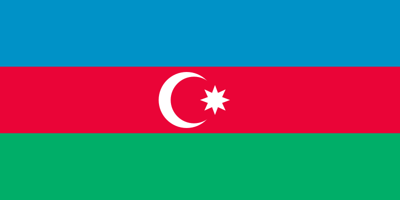
The national flag of the Azerbaijan Republic consists of three equal strips. The upper strip is of blue color, the middle-of red, the lower is green. The blue strip designates the Turkish origin of the Azerbaijan Republic, the red color-its intention to create a modern state and develop the democracy, the green strip-its relation to the Islam civilization. In the middle of the red strip on both sides of the flag there is a white-color crescent and an eight-point star. The relation between the width and the length of the flag is 1 to 2.
The State Emblem
The government of the Democratic Republic of Azerbaijan declared a competition on the national emblem of Azerbaijan on January 30, 1920 and made a decision to present the emblem model on May of the same year. However, due to the collapse of the Azerbaijan democratic Republic On April 28, 1920, the emblem was not approved.
The Supreme Medjlis of the Nakhichevan Autonomous Republic discussed the issue connected with the national emblem and raised petition in the Supreme Council of the Azerbaijan SSR on declaration of a new competition on the national emblem of Azerbaijan on November 17, 1990.
The competition was declared by the decision of the Supreme Council of the Azerbaijan Republic on February 5, 1991. Tens of projects of the emblem were presented during the competition of 1991-1992 and it was also proposed to approve one of the projects developed in 1919-1920.
By the Constitutional Law of the Supreme Council of the Azerbaijan Republic, approved on January 19, 1993, one of the projects, developed in 1919-1920 with certain alterations was confirmed the national emblem of the Azerbaijan Republic.
The National Emblem of the Azerbaijan Republic symbolizes the independence of Azerbaijan. The national emblem is the image of an oriental shield and a semicircle formed by the branches of an oak-tree and ears resting on it. The shield contains the image of a fire in the center of an eight-point star against a background of the colors of the National flag of Azerbaijan.
NATIONAL HOLIDAYS
January 1 - New Year’s Day
January 20 - Day of the Martyrs
March 8 - Women’s Day
March 21 - Novruz Bayrami
May 9 - Victory in WW II Day
May 28 - Republic Day
June 15 - National Salvation Day
June 26 - Army and Navy Day
October 18 - National Independence Day
November 12 - Constitution Day
November 17 - Day of National Revival
December 31 - Day of Solidarity of Azerbaijanis throughout the World
In April 2005, Azerbaijan was elected a member of UN Commission for Human Rights.
On May 10, the United Nations elected 44 of the initial 47 members of its new Human Rights Council in a first round of voting. After the second round of voting, Azerbaijan also took a seat in the new Council.
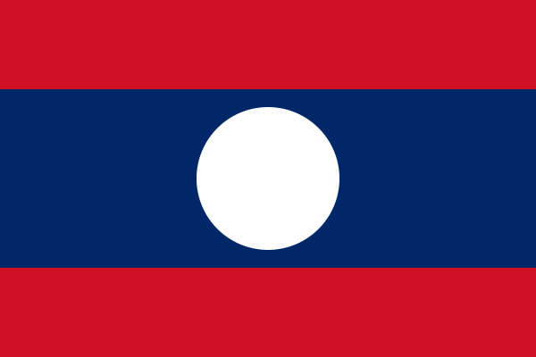
Location : | landlocked country bordered by China, Vietnam, Cambodia, Thailand and Myanmar. |
Area : | 236,800 square Kilometers. |
Climate : | Tropical with rainy season from May to October. |
Population : | 5.9 million. |
Density : | 25 people per square kilometer. |
Religion : | Buddhism (Theravada Buddhism). |
Language : | Lao (English is widely understood in the cities) |
Capital : | Vientiane |
Major Cities : | - Vientiane |
- Savannakhet | |
- Pakse | |
- Luang Prabang | |
Main touristic sites | - Luangphabang, the charm and the serenity of the world heritage “an alive museum of the past ”. |
- Plain of Jars (Xiengkhouang) the 3,000 years stone jars. | |
- That Luang Stupa and Patouxay (triumphal arch) Vientiane City. | |
- Ruins of Wat Phu Champassak temple built from 6th to 8th centuries placed under the UNESCO’s list of the world heritage conservation and Khonephapheng Waterfall, the biggest waterfall of the Mekong river in Champassak province. |
People & Culture :

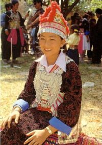
The Lao PDR is a home of multi-ethnic people and multi-cultural society. It has long history of rich variety of cultures and customs.
There are 49 ethnic groups in Laos which speak four major languages:
|


People- Mongolia's Population and Ethnic Groups
Population. In the Conception for development of Mongolia , it is stated that citizens of Mongolia with high levels of creative force, knowledge, education, spiritual and professional expertise are the source of the development of Mongolia .
For the time being the population of Mongolia stands at 2.5 million, which as against that recorded in the 8th Bogd Khan’s Mongolia, i.e. in 1918, has risen as much as 3.7 fold over a more than 80-year period.
The population density of Mongolia is 1.5 persons per square km, making Mongolia one of the most sparsely populated countries in the world.
The natural growth rate per 1000 of the population made up 3.6 per cent in 1980 and in 2000 was reportedly 1.4. In connection with such a drop in the population growth rates, the President of Mongolia issued a resolution on policies to be pursued in this sphere. The resolution underlined that it would be appropriate to carry out a policy aimed at preventing further decline in the population’s annual average growth rates, securing the purity of the Mongolians’ gene pool. For this purpose, the traditions of keeping genealogical records were reinstated to be kept by every household and ancestry and family records of citizens are being carried out with a view to ensuring favorable social, economic, scientific, cultural, natural and psychological environs for Mongolia ’s population growth and safeguarding the purity of the Mongolians’ gene pool.
Ethnic groups. More than 90 per cent of the country’s population constitutes Mongolian nationalities. The core Mongolian nationality, being Khalkha distributed all along the territory of the country, makes up 80 per cent of its population. The other major group, the Kazakhs, makes up about 6 percent of the population and lives in western Mongolia , mainly in Bayan-Ulgii aimag. Many Kazakhs immigrated to Kazakhstan in the early 1990s, but many have since returned.
As for the linguistic reference of the Mongolian population, it relates to the Mongolian group of the Altaic family except for Kazakhs. This group is composed of Khalkh, Durvud, Buryad, Bayad, Uriankhai, Zakhchin, Darkhad, Torguud, Uuld, Myangad, Barga and Uzemchin dialects.
The Mongolian group stemmed from the ancient Mongolian people and Mongolian tribes being parts of the Mongol Empire founded in 1206 by Chinggis Khan. The ancient Mongolian tribes comprised the medieval Aimag (principality) of Mongolian tribes. The current “aimag” of Mongolia means its administrative and territorial unit. That is why the dominant tribes and nationalities that used to comprise the ancient Mongolian group are now spread along all the aimags (provinces) of Mongolia . However, the traditional settlement patterns of the dominant tribes and nationalities of the ancient Mongolian principality still can be easily traced back even now.
Thus, Mongolia viewed as the heart of the Mongolian race, spreading worldwide Mongols who comprise one single family developed from a common ethnic origin.
The Land

Mongolia is one of the few countries in the temperate belt of the northern hemisphere with its vast territory, perfect ecosystem and virgin land. Mongolia ranked as the seventh largest country in Asia for its territory, which covers an area of 1.564.100 sq. km, larger than the overall combined territory of the United Kingdom , France , Germany and Italy . It is one of the land-locked countries. Mongolia lies in 41° 35’ N. Lat and between 87° 44’ and 119° 56’ E. Long in the north of Central Asia . Mongolia bordered to the north by Russia and to the east, south and west by China . Its total borderline is 8161.8 km long, 3485 km of which is with Russia and 4676.8 km is with China . Within Mongolia , the Mongol Altai Mountains occupy an extensive area of 2392 km from west to north. There is a distance of 1259 km between the Soyon mountain ranges in the Gobi in the south. The nearest body of water to Mongolia is the Yellow Sea , 700 km away in the east.
Culture
Since the political and economic transition of the 1990s, the country has gone through many changes quickly, and there are many more ahead. Its cultural community seeks new and different ways to preserve and sustain arts and culture in Mongolia 's new economy.
The Government directed the Education, Culture and Science Minister to approve a "Master Plan for the Development of Mongolia's Culture and Art" with a view to define policy guidelines for the next ten years. /2003 2013/.
The literacy. Mongolia is the one of the oriental countries with an ancient and unique culture. The Mongolian script created by Mongols is one of the six most recognized alphabets used in the contemporary world. The earliest monument, which scientists call "Chinggis' stone inscription", was created in 1225. It was dedicated to Esunkhui- hero, who managed to shoot all targets from a distance of 500 meters during the archers' competition when Chinggis Khaan celebrated his victory over the Sartuul tribes.

In 1204 by the order of Chinggis Khaan, the Mongolian script had a state status and the 800th anniversary of this event will be celebrated in Mongolia next year.
The Mongols developed their alphabet many centuries ago, but because of their nomadic way of life and continued wars and campaigns, very few ancient literary monuments have actually survived.
All the best works of history, culture, philosophy and literature, written in Mongolian, are kept in Mongolian Central Library with great care. From the 1990s, the renaissance of Mongolian script began by teaching it in all secondary schools. As a result, nearly half of all Mongols now write and read in traditional script. It should be noted that the State Ikh Khural approved the Law on State Official Language.

History & People
 The Philippines is the third largest English speaking country in the world. It has a rich history combining Asian, European, and American influences. Prior to Spanish colonization in 1521, the Filipinos had a rich culture and were trading with the Chinese and the Japanese. Spain's colonization brought about the construction of Intramuros in 1571, a "Walled City" comprised of European buildings and churches, replicated in different parts of the archipelago. In 1898, after 350 years and 300 rebellions, the Filipinos, with leaders like Jose Rizal and Emilio Aguinaldo, succeeded in winning their independence.
In 1898, the Philippines became the first and only colony of the United States. Following the Philippine-American War, the United States brought widespread education to the islands. Filipinos fought alongside Americans during World War II, particularly at the famous battle of Bataan and Corregidor which delayed Japanese advance and saved Australia. They then waged a guerilla war against the Japanese from 1941 to 1945. The Philippines regained its independence in 1946.
Filipinos are a freedom-loving people, having waged two peaceful, bloodless revolutions against what were perceived as corrupt regimes. The Philippines is a vibrant democracy, as evidenced by 12 English national newspapers, 7 national television stations, hundreds of cable TV stations, and 2,000 radio stations.
Filipinos are a fun-loving people. Throughout the islands, there are fiestas celebrated everyday and foreign guests are always welcome to their homes. (Source: www.visitmyphilippines.com)
Geography
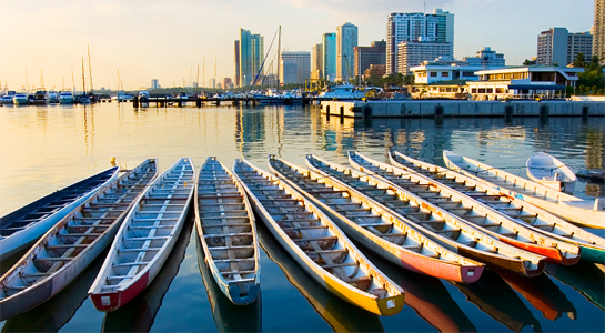
 The PHILIPPINES stands at the crossroads of the developed western world and the Orient. It lies in the heart of Southeast Asia, stretching more than 1,840 kilometers. Composed of 7,107 islands, the Philippines is readily accessible to the different capitals of the world. Its three main islands are Luzon, Visayas and Mindanao.
The South China Sea washes its western shores. Taiwan, China and Hong Kong are northern neighbors and further north is Japan. To the west lie Southeast Asian countries such as Singapore, Malaysia and Thailand. An arm of the archipelago reaches out towards Borneo and at its feet stands the chain of Indonesian islands. To the east and south, the waters of the Pacific Ocean sweep its headlands, looking out towards Micronesia and Polynesia.
Its unique location has made the Philippines the commercial, cultural and intellectual hub of Asia from the dawn of history.
Climate
November to February is the coolest months and a good time to visit the Philippines as far as weather is concerned. Meanwhile, March to May is the summer months in the country and are classified as hot and dry. June to October is rainy, with the months between July and September characterized by typhoons.
The average temperature in the Philippines is 86°F / 30°C; average humidity is 77%. Some parts of the country such as Cebu and its neighboring provinces in the Visayas are warm and comfortable in all seasons and can be visited throughout the year.

History of Qatar
Evidence of early habitation in Qatar that can be traced as far back as to the 4th century BC appeared in many artifacts such as inscriptions, rock carvings, flint spearheads and examples of pottery which were all uncovered  by the Danish (1965), the British (1973) and the French (1976) expeditions. Researchers knew al-Wasil hills since 1957 as an important site of Stone Age archeology. About 200 archeological sites of the prehistoric age were discovered during the eight years of the work of the Danish expedition from 1965 to 1975. Several sites of various periods in the Stone Age were discovered to the east of Um Bab. Other sites were found in the southernmost border near Soudanthil. An important site for the manufacture of flint tools, which probably goes back to the Mesolithic Stone Age, was discovered at Umm Tag to the south west of Dukhan; and new sites were discovered to the south east of Mesaieed. The archeological surveys revealed that the Ubaid civilization, which flourished in southern Iraq and the northern parts of the Arabian Gulf, had also reached the Qatar peninsula.
In the 5th century BC, the Greek historian Herodotus referred to the seafaring canaanites as the original inhabitants of Qatar. Further, the geographer Ptolemy showed in his map of the Arab world 'gatara' as believed to refer to the Qatari town of Zubarah, which has acquired the fame of being one of the most important trading ports in the gulf region at the time.
Qatar in the Islamic History
In the Islamic history in the middle of the 7th century AD, the Qatar peninsula and the surrounding region were under the rule of the Al Munzir Arabs. Their king, al-Munzir Ibn Sawi al-Tamimi,  embraced Islam, and Qatar entered the realm of Islamic civilization and has participated in all its successive stages and eras.
The presence of Qatar in Arabic and Islamic literature and history was very noticeable. Poets expressed their admiration of Qatar naval fleet which was assembled to transport the Islamic army under the leadership of Abu al-Al'a al-Hadrami.
Arab historians and travelers marked the fame and outstanding bravery of the Qatari poet Qatari Ibn al-Fujaah. In his publication Mu'jam al-Buldan', Yaqut al-Hamawi, a well known Arabian geographer, mentioned Qatar for its fine striped woven cloaks, known at the time as Qatari cloaks, and for the Qataris' noticeable skills in the improvement and fine finishing of spears, known at the time as the Khattiyah spears.
Under the Abbasid state during the 8th century AH (14th century AD), Qatar experienced great economic prosperity and pledged a great deal of financial support towards maintaining the Caliphate in Baghdad. Evidence of such support can be gleaned from the inscriptions of Murwab fort on the western coast of the peninsula, which bears the marks of the Abbasid architectural style.
During the 10th century AH (16th century AD), the Qataris aligned with the Turks to drive out the Portuguese. Subsequently, Qatar, like the entire Arabian Gulf region, came under the Turkish rule for four successive centuries. Ottoman sovereignty, however, was only nominal as the real power and control were in the hands of the sheikhs and princes of local Arab tribes.
Qatar in the 20th Century
Qatar continued to maintain its ties with the state of the Ottoman Islamic Khalifate and recognized the khalifate's nominal sovereignty until early in the 20th century in spite of the fact that the Ottoman rule in the Gulf region and the Arabian  Peninsula was gradually weakened. In those circumstances Qatar chose not to commit itself to any protection arrangements other than the 1868 treaty, which Sheikh Mohammed Bin Thani had signed with Britain. In 1916 Britain was able to conclude with Qatar a protection treaty that was finally ratified on the 23 of March 1918 after Sheikh Abdullah Bin jassim had signed the original and translated versions. Britain then moved to the stage of its physical presence in Qatar after the ratification of the amended treaty in 1935. The amended version ensured the cancellation of the 'frozen' articles dealing with the political British representation in Qatar in the old treaty, and provided for the establishment of postal and telegraphic services, airports and other facilities, notwithstanding that no British political representative had come to Doha until 1939.
Oil exploration operations took about 14 years (1935 - 1949), and in spite of the first signs of success at Dukhan field towards the end of 1939, operations had to stop for 4 years because of the Second World War. In 1949 oil started to flow in commercial amounts, and in December in the same year the first ship left the shores of Qatar bearing a consignment of crude oil.
Before that, a 10-year period of hardship, which was marked with food shortages and steep increase in the price of commodities, hit the country from 1939 to 1949 in the aftermath of the Second World War and the sharp fall in revenues from pearling.
Despite the fact that Qatar was not independent yet, it tried since the 1960s to engage in some international activity by joining some technical UN organizations such as the UNESCO and the World Health Organization. It also participated in the conferences of oil producing countries and the 14th session of the Arab League's cultural committee, held in Cairo on the 21st of January 1961.
 After Britain had decided to withdraw from the entire region in 1968, a decree-law No (1 1) for 1969 was issued to establish a department for foreign affairs, which had formed the nucleus of the present Ministry of Foreign Affairs..
The first Qatari constitution, which was issued as a provisional basic statute in 1970, stipulated, by decree No (35) issued on 29th May 1970, the formation of the first Council of Ministers in the history of Qatar. Several laws started to flow thereafter, outlining the responsibilities of ministers and jurisdiction of ministries and government departments in line with the basic statute.
The first meeting of the first Council of Ministers in Qatar was held in the 3rd June 1970, with 10 portfolios. Independence was proclaimed on 3rd September 1971.
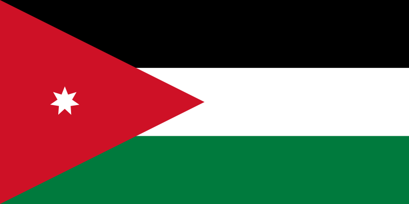
History of Jordan
From Antiquity to Modernity
Jordan is a land steeped in history. It has been home to some of mankind’s earliest settlements and villages, and relics of many of the world’s great civilizations can still be seen today. As the crossroads of the Middle East, the lands of Jordan and Palestine have served as a strategic nexus connecting Asia, Africa, and Europe. Thus, since the dawn of civilization, Jordan’s geography has given it an important role to play as a conduit for trade and communications, connecting east and west, north and south. Jordan continues to play this role even today.
Because of its central location, the land of Jordan is a geographic prize that changed hands many times throughout antiquity. Parts of Jordan were included in the dominions of ancient Iraq, including the Sumerian, Akkadian, Babylonian, Assyrian and Mesopotamian Empires. From the west, Pharoanic Egypt extended its power and culture into Jordan, while the nomadic Nabateans built their empire in Jordan after migrating from the south. Finally, Jordan was incorporated into the classical civilizations of Greece, Rome and Persia, the relics of which are scattered across the Jordanian landscape. Since the mid-seventh century AD, the land of Jordan has remained almost continuously in the hands of various Arab and Islamic dynasties.
The second geographical factor that has helped shape the history of Jordan concerns climate. Only the northern highlands and the Jordan Valley have received enough rainfall to support large populations. Therefore, this area has always been more settled by farmers, villagers and townspeople. Most of the urban civilizations of Jordan have been based in these fertile lands. To the south and east, meanwhile, there is very little rainfall and no rivers for irrigation. These desert areas, which compromise the majority of Jordan, have rarely supported large settled populations. In some periods, there appears to have been no settled population at all. The lifestyle of the Bedouin inhabitants of these desert lands has remained similar in some respects to that of their Edomite or Nabatean predecessors. The contrast between the pastoral "desert" and the agricultural ‘sown" is particularly pronounced in Jordan, and much of the area’s history can be linked to population shifts between large urban centers and more dispersed, nomadic tribal groups.
Prehistoric Jordan
During the Paleolithic period (c. 500,000-17,000 BC), the inhabitants of Jordan hunted wild animals and foraged for wild plants, probably following the movement of animals seeking pasture and living near sources of water. The climate during this period was considerably wetter than today, and therefore large areas of modern-day desert were open plains ideal for a hunting and gathering subsistence strategy. Evidence has also been found of Paleolithic inhabitation near a large expanse of water at Azraq. Paleolithic man in Jordan left no evidence of architecture, and no human skeleton from this period has yet been found. However, archeologists have uncovered tools from this period such as flint and basalt hand-axes, knives and scraping implements. Ancient man also left clues to the nature of his existence beginning in Paleolithic times and continuing through the Neolithic and Chalcolithic eras.
It was during the Epipaleolithic period (c. 17,000-8500 BC), also known as the Mesolithic period or Middle Stone Age, that the nomadic hunter-gatherers began to settle. They domesticated animals such as gazelles and dogs, while supplementing their diet by cultivating wild grains. Architectural remains have been found from the Epipaleolithic period which indicate the construction of small circular enclosures and hut foundations. Evidence exists of Epipaleolithic settlements around Beidha in southern Jordan, as well as in the Jordan Valley, the eastern desert region, and at Jericho in the West Bank.
During the Neolithic period (c.8500-4500BC), or New Stone Age, three great shifts took place in the land now known as Jordan. First, people settled down to community life in small villages. This corresponded to the introduction of new food sources – such as cereal agriculture, domesticated peas and lentils, and the newly-widespread practice of goat herding – into the diet of Neolithic man. The combination of settled life and "food security" prompted a rise in population which reached into the tens of thousands.
The second basic shift in settlement patterns was prompted by the changing weather of the eastern desert. The area grew warmer and drier, gradually becoming virtually uninhabitable throughout much of the year. The distinction between the desert to the east and the "sown" areas to the west dates back to this watershed climatic change, which is believed to have occurred from around 6500-5500 BC.
The most significant development of the late Neolithic period, from about 5500-4500 BC, was making the pottery. Earlier attempts to fashion pottery from plaster have been discovered, but it was during the late Neolithic period that man began to systematically create vessels from clay. It is likely that pottery making was introduced to the area from artisans arriving from the seminal civilizations developing to the northeast, in Mesopotamia.
Indeed, there seems to have been a significant cultural exchange among the regional settlement centers throughout the Levant region. The need for materials such as basalt, bitumen, seashells and minerals for jewelry stimulated external relations and a diffusion of ideas throughout the region. When population centers became a focus for trade, there grew a need for established trade and communications routes, which in turn stimulated the growth of more settlements and the continuation of trade.
During the Chalcolithic period (4500-3200 BC), copper was smelted for the first time. It was put to use in making axes, arrowheads and hooks, although flint tools continued to be used for a long time. Chalcolithic man relied less on hunting than in Neolithic times, instead focusing more on sheep and goat-breeding and the cultivation of wheat, barley, dates, olives and lentils. In the desert areas the lifestyle was probably very similar to that of modern Bedouins.
Tuleitat Ghassul was a large Chalcolithic village in the Jordan Valley. Houses there were built of sun-dried mud bricks with roofs made of wood, reeds and mud. Some dwellings were based on stone foundations and many were planned around large courtyards. The inhabitants of Tuleitat Ghassul used the walls of their houses for artistic or ceremonial purposes, painting bright images of masked men, stars and geometric motifs, perhaps connected with religious beliefs.
‘Ain Ghazal
The largest Neolithic site in Jordan is at ‘Ain Ghazal ("spring of the gazelle") near Amman. Since 1982, a series of excavations have unearthed a stone village of great importance. At one point, a community of 1,500 to 2,000 people may have lived in the vicinity of ‘Ain Ghazal, making it one of the largest of over 150 Neolithic villages discovered so far in the Middle East. ‘Ain Ghazal displayed sophisticated social organization and planning, as its large number of buildings was divided into three distinct districts. The houses were rectangular with several rooms, and some of them had plastered floors.
Faunal and floral remains discovered at the site indicate that ‘Ain Ghazal was located favorably in relation to a variety of different ecological zones. This provided an abundance of food and a protein-rich diet that include a variety of meat and vegetables. A diverse array of bones found at ‘Ain Ghazal indicates the strong possibility that goats and cattle may have been domesticated. By taking advantage of favorable environmental conditions, the residents of ‘Ain Ghazal were able to diversify their food supply, thus safeguarding against famine. Bountiful harvests also allowed some segments of the society to pursue activities other than food production.
For instance, it seems as though Neolithic man practiced ancestor veneration and engaged in burial rites for the dead. This is indicated by the discovery of human skulls reworked with plaster over the cheekbones and nose, and with bitumen in the eye sockets. Examples of these have been found at sites in Jordan (‘Ain Ghazal), Palestine and Syria.
‘Ain Ghazal appears to have been a major center of artistic production during the Pre-Pottery Neolithic period, larger and more significant than its contemporaries – Jericho, on the West bank, and Beidha, to the north of Petra. Over 100 animal and human figurines have been discovered at ‘Ain Ghazal. Even more impressive is the discovery of human statues and busts made from plaster, with colorful features perhaps designed to resemble individuals.
Recently, archeologists finished restoring what may be one of the world’s oldest statues. Found at ‘Ain Ghazal, the relic is thought to be 8000 years old. The statue is just over one meter high and is of a woman with huge eyes, skinny arms, knobby knees and carefully depicted toes.
Rise of the City-States
By about 3200 BC, Jordan had developed a relatively urban character. Many settlements were established during the Early Bronze Age (c. 3200-1950 BC) in various parts of Jordan, both in the Jordan Valley and on higher ground. Many of the villages built during this time included defensive fortifications to protect the inhabitants from marauding nomadic tribes still inhabiting the region. Water was channeled from one place to another and precautions were even taken against earthquakes and floods.
Interesting changes took place in burial customs during this period. At Bab al-Dhra, a well-preserved site in Wadi Araba, archeologists have discovered over 20,000 shat tombs with multiple chambers. These tombs are thought to have contained the remains of 200,000 corpses. There also charnel houses of mud-brick containing human bones, pots, jewelry and weapons. The hundreds of dolmens scattered throughout the mountains of Jordan are dated to the late Chalcolithic and Early Bronze ages. It is possible that the dolmens are evidence of new peoples from the north bringing with them different burial traditions.
Spectacular advances in urban civilization were taking place during this period in Egypt and Mesopotamia, where writing developed before 3000 BC. Although writing was not really used in Jordan, Palestine and Syria until over a thousand years later, archeological evidence indicates that Jordan was in fact trading with Egypt and Mesopotamia during the Early Bronze Age.
From 2300-1950 BC, any of the large, fortified hilltop towns constructed during the Early Bronze Age were abandoned in favor of either small, unfortified villages or a pastoral lifestyle. Archeologists do not know for sure what prompted this shift, but it is possible that many cities were destroyed by an earthquake. It is clear, however, that a sharp climatic change at this time resulted in less rainfall and higher temperatures across the Middle East. The predominant theory is that many of these Early Bronze Age towns were victims of changes in climate and political factors which brought an end to a finely-balanced network of independent "city-states."
During the Middle Bronze Age (c. 1950-1550 BC), people began to move around the Middle East to a far greater extent than before. Trading continued to develop between Egypt, Arabia and Greater Syria, resulting in the refinement and spread of civilization and technology. The creation of bronze out of copper and tin resulted in harder and more durable axes, knives and other tools and weapons. It seems that during this period large and distinct communities arose in parts of northern and central Jordan, while the south was populated by a nomadic, Bedouin-type of people known as the Shasu.
A new and different type of fortification appeared at sites like Amman’s Citadel, Irbid, Pella and Jericho. The towns were surrounded by ramparts made of earth embankments. The slope was then covered in hard plaster, making it slippery and difficult for an enemy to climb. Pella was enclosed by massive walls and watchtowers.
It was once thought that during the 18th century BC much of Syria, Jordan and Palestine were overturn by a military aristocracy from northern Mesopotamia known as the Hykos, who went on to conquer much of Egypt and help overthrow the Middle Kingdom there. Now, however, archeologists believe that the Hykos – a Greek form of the ancient Egyptian hkaw haswt, which means "rulers of foreign lands" – were from Jordan and Palestine is usually blamed on the Egyptian armies pursuing the Hykos, although there is little direct evidence of Egyptian involvement.
The Egyptian Pharaoh Tuthmosis III, who acceded as ruler in 1482 BC, succeeded in settling many of the internal disputes which had diverted Egypt’s attention away from the outlying northern areas. He carried out at least 16 military expeditions and set up an empire in Canaan (Palestine, Jordan and Syria) after the successful conclusion of a seven-month siege of the combined Canaanite forces at Megiddo, in northern Palestine. Tuthmosis installed rulers of his choice in major towns and introduced a system of Egyptian influence existed throughout Jordan and Palestine during this period. In the north, meanwhile, the Egyptians fought a series of inconclusive battles against the kingdoms of the Mitannians and Hittites for control of Syria.
The relative peace brought by the Egyptians encouraged international trade, especially with the Mediterranean and Aegean. Pottery from Mycenaean Greece and Cyprus is found throughout Palestine and Jordan. Originally it probably contained fine oils and perfumes, but it was also used as elegant tableware or buried with the dead. In this relatively optimistic and prosperous period, a large number of new towns and temples were constructed.
The Late Bronze Age was brought to a mysterious end around 1200 BC, with the collapse of many of the Near Eastern and Mediterranean kingdoms. The main cities of Mycenaean Greece and Cyprus, of the Hittites in Anatolia, and of Late Bronze Age Syria, Palestine and Jordan were destroyed. It is thought that this destruction was wrought by the "Sea Peoples," marauders from the Aegean and Anatolia who were eventually defeated by the Egyptian pharaohs Merenptah and Rameses III. One group of Sea Peoples were the Philistines, who settled on the southern coast of Palestine and gave the area its name.
The Israelites may have been another cause of the Late Bronze Age devastation in Palestine. Although the archeological record does not always agree with the Biblical narrative, it is certain that the Israelites destroyed many Canaanite towns including Jericho, Ai and Hazor.
Amman
The seven hills of Amman are an enchanting mixture of ancient and modern. Honking horns give way to the beautiful call to prayer which echoes from the stately minarets which grace the city. Gleaming white houses, kabab stalls and cafes are interspersed with bustling markets – known in Arabic as souqs – and the remains of civilizations and ages long past. Sunset is perhaps the best time to enjoy Amman, as the white buildings of the city seem to glow in the fading warmth of the day. The greatest charm of Amman, however, is found in the hospitality of its residents. Visitors of Amman – and the rest of Jordan, for that matter – are continually surprised by the genuine warmth with which they are greeted.
Amman is built on seven hills, or jabals, each of which more or less defines a neighborhood. Most jabals once had a traffic circle, and although most of these have now been replaced by traffic lights, Amman’s geography is often described in reference to the eight circles that form the spine of the city. First Circle is located near downtown, and the series extends westward through Eight Circle.
History
Amman has served as the modern and ancient capital of Jordan. It is one of the oldest continuously inhabited cities in the world, with a 1994 excavation uncovering homes and towers believed to have been built during the Stone Age, circa 7000 BC. There are many Biblical references to the city, which by about 1200 BC had become the Ammonite capital of Rabbath-Ammon. The Ammonites fought numerous wars with Saul, David and others.
The history of Amman between the end of its Biblical references (around 585 BC) and the time of the Ptolemies is unclear. We do know that the city was renamed Philadelphia after the Ptolemaic ruler Philadelphus in the third century BC. The city later came under Seleucid and also Nabatean rule, but the Roman general Pompey’s annexation of Syria in 64 BC and capture of Jerusalem one year later laid the foundations for the Decapolis League, a loose alliance of ten free city-states under overall allegiance to Rome. Philadelphia was part of the Decapolis, as were other Hellenized cities in Jordan including Gerasa (Jerash), Gadara (Umm Qais), Pella and Arbila (Irbid).
Under the influence of Roman culture, Philadelphia was replanned and reconstructed in typically grand Roman style with a colonnaded street, baths, an amphitheater and impressive public buildings.
During the Byzantine period, Philadelphia was the seat of a Christian bishop, and several expansive churches were built. The city declined somewhat during the late Byzantine years, and was overrun by the Persian Sassanians in 614 AD. Their rule was short-lived, however, collapsing before the Arabian armies of Islam around the year 635. The name of the city then returned to it Semitic origin of Ammon, or "Amman." It remained an important stop on the caravan routes for many years, but eventually trade patterns shifted and dried up the lifeblood of Amman. The city declined to little more than a provincial village for many centuries.
Amman’s "modern" history began in the late 19th century, when the Ottomans resettled a colony of Circassian emigrants there in 1878. Many of their descendants still reside in Amman. During that time and the early decades of the 20th century, neighboring city of Salt was more important as a regional administrative and political center. However, after the Great Arab Revolt secured the state of Transjordan, Emir Abdullah bin al-Hussein made Amman his capital in 1921.
Since then, the city has grown rapidly into a modern, thriving metropolis of well over a million people. Amman’s growth has been driven largely by political events in the region, and especially by the Arab-Israeli conflict. After the wars of 1948 and 1967, successive waves of Palestinian refugees ended up in Amman. Moreover, the city’s population was further expanded by another wave of immigrants arriving from Iraq and Kuwait during the 1990-91 Gulf Crisis.
Sites of Interest
Most of Amman’s noteworthy historical sites are clustered in the downtown area, which sits at the bottom of four of Amman’s seven hills, or jabals. The ancient Citadel, which towers above the city from atop Jabal al-Qala’a, is a good place to begin a tour of the city. The Citadel is the site of ancient Rabbath-Ammon, and excavations here have revealed numerous roman, Byzantine and early Islamic remains. The most impressive building of the Citadel, known simply as Al-Qasr ("the Palace"), dates back to the Islamic Umayyad period. Its exact function is unclear, but it indicates a monumental gateway, an audience hall and four vaulted chambers. A colonnaded street also runs through the complex. To the north and northeast are the ruins of Umayyad palace grounds.
Close to al-Qasr lie the remains of a small Byzantine basilica. Corinthian columns mark the site of the church, which is thought to date from the sixth or seventh century AD. About 100 meters south of the church is what is thought to have been a temple of Hercules, today also known as the Great Temple of Amman. The temple was built in the reign of the emperor Marcus Aurelius (161-180 AD), and is currently under restoration.
Also on Citadel Hill, just northwest of the Temple of Hercules, is the Jordan Archeological Museum. This small museum houses an excellent collection of antiquities ranging from prehistoric times to the 15th century. There is an exhibit of the Dead Sea Scrolls, a copy of the Mesha Stele (see Moab and the Mesha Stele for explanation) and four rare Iron Age sarcophagi. Museum hours are 09:00-17:00 daily except Tuesdays. On Fridays and official holidays the museum is open from 10:00-16:00.
Two small museums are built into the foundations of the Roman Theater. The Jordan Folklore Museum is in the right wing of the theater and displays a collection of items showing the traditional life of local people. At the other end of the theater stage, the Museum of Popular Traditions displays traditional Jordanian costumes, including fine embroidery and beautiful antique jewelry. It also houses several sixth-century mosaics from Madaba and Jerash. Both the Museum of Popular Traditions and the Jordan Folklore Museum are open daily 09:00-17:00, and close on Tuesday.
To the northeast stands the small theater, or Odeon, which is still being restored. Built at about the same time as the Roman Theater, this intimate 500-seat theater is used now as it was in Roman times, for musical concerts. Archeologists think that the building was originally covered with a wooden or temporary tent roof to shield performers and audiences from the elements. Heading southwest from the theater complex, Philadelphia’s chief fountain, or Nymphaeum, stands with its back to Quraysh Street. Much of the fountain, which was completed in 191 AD, is hidden from public view by private houses and shops. The Nymphaeum is believed to have contained a 600 square meter pool, three meters deep, which was continuously refilled with fresh water. Jordan’s Department of Antiquities is currently excavating the Nymphaeum, and ultimately hopes to restore the site to its original structure by 2010.
From the Nymphaeum, the short stroll to the King Hussein Mosque bustles with pedestrians, juice stands and vendors. The area around the King Hussein Mosque, also known as al-Husseini Mosque, is the heart of modern downtown Amman. The Ottoman-style mosque was rebuilt in 1924 on the site of an ancient mosque, probably also the site of the cathedral of Philadelphia. Between the al-Husseini Mosque and the Citadel is Amman’s famous gold souq, which features row after row of glittering gold treasures.
Moab and the Mesha Stele
The Kingdom of Moab was located between the Zarqa Valley and Wadi Mujib, and extended from the desert to the Dead Sea. Moab is best known from the Mesha Stele, a stone which records the Moabite King Mesha’s successful rebellion against the kings of Israel in the ninth century BC. The overall theme of Mesha’s account is that he liberated Moabite territory from the Israelites by capturing occupied cities north of the River Arnon (Wadi Mujib). The stele states that the Moabite rebellion took place during the reign of the Israelite King Ahab, who was at that time distracted by the Aramaeans’ capture of Ramoth-Gilead. It is reasonable to assume that, as Moab was a vassal state of the Israelites at that time, King Mesha did not possess a large and well-trained army. However, the advances of the Aramaeans gave them the opportunity to reconquer their territories without strong opposition.
According to the stele, within a few years King Mesha captured a number of cities, including Dhiban, Madaba, Nebo, and other towns along the King’s Highway. Mesha made Dhiban into his capital city, and built a royal citadel and a "high place" for the god Chemosh there. He also had a basalt rock shaped and inscribed there with an enduring record of his rebellion against the Israelites.
There are vast discrepancies between the account recorded on the Mesha Stele and the biblical narrative. According to the Bible’s brief depiction of the scenario, after the death of King Ahab (c. 869-850 BC), the Moabites rebelled against King Jehoram, who responded by mounting a counter-offensive with the assistance of King Jehoshaphat of Judah. Together the two armies approached Moab from the south, avoiding Moab’s strong northern defenses. After seven days of marching, they ran out of water, and the two kings consulted Prophet Elisha, who foretold that rain would soon fill the dry stream beds. Indeed, when the rain came, it carried so much dirt that it was colored bright red in the early morning light. The Moabites saw the water and assumed that their enemies had turned against each other, causing the water to run red with blood. They considered it an opportune moment to attack, but were heavily defeated by the Israelites, who destroyed their towns and land.
The Bible says that the Moabite armies retreated to the city of Kir-hareseth (modern Karak), where King Mesha offered his eldest son as a sacrifice to Chemosh, the god of Moab. For some reason, this terrified the Israelites, so they withdrew from the city and returned to their own country.
It is understandable that the biblical account would downplay the defeat of the Israelites, while the Mesha Stele perhaps exaggerates the victories of King Mesha. The Mesha Stele is the longest original inscription dating from the Biblical period to be found so far in Jordan, and it continues to intrigue scholars even today. Copies of the original can be found at the Madaba Museum and at the Jordan Archeological Museum near the Citadel in Amman. Unfortunately, the original was broken soon after it was unearthed in Dhiban in 1868 by a German missionary, Frederick Klein, who was journeying from Salt to Karak. It seems that local tribesmen who owned the rock broke it into many pieces by placing it on a fire and then dousing it with water, perhaps attempting to win more money for their property. Fortunately, an imprint of the stone was taken before the Mesha Stele was destroyed.

Early history
The archaeological excavations carried out recently have proved the presence of human beings in the territory of Vietnam since the Paleolithic Age or the Old Stone Age (300,000 - 500,000 years). In the Neolithic Age (New Stone Age), Hoa Binh - Bac Son cultures (about 10,000 BC) had witnessed the development of agriculture and animal husbandry, including even the technique of paddy rice cultivation.
The Vietnamese as an ethnic group had been formed and developed early in the Red river and Ma river delta situated in northern part of the present-day Vietnam. Generations to generations, people moved from highland and mountainous areas to the plains, developed new lands for cultivation. They constructed a system of irrigation dams and dykes to tame the mighty Red River, the river that brought about several devastating floods every year. It is the process of continuous labor to control water - to fight against flood, storm and drought, to build up irrigation dams and canals for agricultural cultivation that formed the paddy rice civilization and the commune culture.
In the Bronze Age, a unique and distinct civilization had been formed that reached a high level in technical skill as well as art - the brilliant Dong Son culture. The recent ethnological, historical and archaeological studies and researches have asserted the existence of the Hung Kings' period in Van Lang Kingdom (later Au Lac Kingdom) about 1000 years BC. In 200 BC, Au Lac Kingdom was invaded and annexed into the giant empire of the Han feudalism in the north. Nevertheless, the ten-century domination of Chinese feudalism could not assimilate Vietnamese culture and break the Viet people's brave resistance.
The Dai Viet
In the 10th century AD, the Vietnamese had won their freedom and built up an independent state named Dai Viet. The country was under the ruling of many national feudal dynasties, among which the most important ones are the Ly Dynasty (11th and 12th century), the Tran Dynasty (13th and 14th century), the Le Dynasty (15th, 16th and 17th century) with their centralized administration, strong army forces and a highly developed economy and culture. During this period, Vietnam as a nation had to ceaselessly fought against the vicious conquering conspiracies of Chinese and Mongolian feudal empires. Vietnam's long and tough struggles of resistance against the invasions of the Song (11th century), the Yuan or the Mongols (13th century), the Ming (15th century) had acquired glorious victories. Vietnam became stronger, all its ethnic groups became more united and the country moved into a new prosperous period after each struggle.
Dong Son culture which was enriched by the influence of Chinese culture developed from centuries to centuries in a framework of an independent state. Buddhism and Confucianism entered Dai Viet and brought with them many popular cultural features and distinct forms. Nonetheless, Vietnam still preserved its own language and a highly developed agricultural civilization.
In the 17th and 18th century, feudalism in Vietnam was considerably weakened. Peasants ceaselessly rose up in revolts that led to the Tay Son movement (1771-1802). Tay Son overthrew all regional feudal lordship that divided the country into two parts, united the country and chased away the Qing (Manchus) invaders from China, simultaneously implemented many social and cultural reforms. However, with foreign aid, Nguyen Anh soon took over the ruling power and the Nguyen Dynasty was established, which was the last royal dynasty in Vietnam.
Struggle for national liberation
In the middle of 19th century (1858), French colonialists began to invade Vietnam. The incompetent government of the Nguyen gradually gave in and from 1884, French colonists established a protectorate and a colonial government that controlled the whole territory of Vietnam. In the early days, resistant movements of the Vietnamese people under the leadership of intellectual patriots like the literate, cultured people and scholars broke out everywhere, but they all failed in the end.
Nguyen Ai Quoc, who later became President Ho Chi Minh, traveled abroad to find the way to save the country. He laid the foundations for the Vietnam Communist Party, which was founded on 3rd February 1930. Under the leadership of the Communist Party, the Vietnamese people rose up against French colonization and Japanese occupation, organized the Great National Uprising in August 1945 and established the Democratic Republic of Vietnam on 2nd September 1945.
Being confronted with aggressive schemes and intervention of France and the United States, the newly born Democratic Republic of Vietnam had to carry out the thirty-year war of resistance. The coming back of French aggressive troops had resulted in the nine-year war of resistance (1945-1954) which ended by the famous victory of Vietnam in Dien Bien Phu and the 1954 Geneva Agreement on Vietnam. According to this Agreement the country was temporarily partitioned into North Vietnam and South Vietnam by the 17th parallel, which should be reunified within two years (1956) through a general election held all over Vietnam. The northern part of Vietnam (the Democratic Republic of Vietnam with its capital Hanoi) was placed under the control of the Vietnam Workers' Party. The southern part (the Republic of Vietnam), which was controlled by a pro-French administration and later, a pro-American administration, had its capital in Sai Gon. The Sai on government used all its forces to prevent the election, suppressed and killed former participants in the resistance movement. The situation led to the national movement fighting for peace and unification of the country. The Sai Gon government could not suppress the aspiration of all Vietnamese people to unify the country, especially since the National Front for Liberation of South Vietnam was established on 20th December 1960.
In order to maintain the Sai Gon regime, the United States increased its military aid to the Sai Gon government. Particularly, in the middle of the '60s, half-million American troops and their allied troops were sent to South Vietnam in direct military intervention. From 5th of August 1964, they started bombarding North Vietnam. In spite of that, following president's Ho Chi Minh's teaching "Nothing is more precious than independent and freedom", the Vietnamese people bravely and firmly stood up and won numerous victories in the northern as well as southern part of the country. In 1973, Washington had to sign the Paris Agreement on the restoration of peace in Vietnam and the withdrawal of all American troops from Vietnam.
Reunification
In the spring of 1975, the patriotic armed forces of Vietnam swept across the country in the great general offensive and overthrew the Saigon government. The southern part of Vietnam was liberated and the country was united as one.
On 25th April 1976, the Democratic Republic of Vietnam was renamed into the Socialist Republic of Vietnam, which governs both northern and southern parts in its territory.
In 1977, Vietnam became a member of the United Nations.
After many years of prolonged war, the country was heavily devastated. In the 1975 - 1986 period, Vietnam had to cope with innumerable difficulties. The aftermath of war, social evils, the mass flow of refugees, war at the southwest border against the genocidal policies of Pol Pot government in Cambodia, the dispute at the northern border, the isolation and embargo from the United States and Western countries, plus continual natural calamities ...put Vietnam before tremendous tough challenges. Moreover, those difficulties became more severe due to subjective reasons such as hastiness and impatience, and voluntarism in rebuilding the country regardless of specific actual conditions. Early in the 80s, Vietnam witnessed the most serious ever socio-economic crisis, the inflation rate rose up to a record 774.7% in 1986.
Economic renovation: Doi Moi
Since 1986, the government launched the "Doi Moi" or all-round renovation process, stepping in the general development trend and the process of gradual globalization and regionalization. The 6th Congress of Vietnam Communist Party in December 1986 strictly self-criticized its mistakes in the past years, assessing carefully its achievements, analysing mistakes and drawbacks, setting forth all-round renovation policy. With top priority being given to economic reform for creating a multi-sector market economy regulated by the Government, at the same time consolidating legal environment and renovating Party's and State's structure. Since then the Vietnamese economy became opened and transformed from centralized planned economy heavily based on imports to a market-oriented one. The self-determination of financing was introduced. All aimed at budget balancing and promoting exports. As from 1989, Vietnam began to export about 1 - 1.5 ton of rice, inflation rate gradually decreased (the rate stood at 67.4% in 1990), living standards were improved, democracy got enhanced, national defense and internal security got firmly consolidated, the external relations were broadened freeing the country from blockage and isolation.
In June 1991, the VIIth Congress of the Vietnam Communist Party reaffirmed its determination to pursue the renovation process overcoming difficulties and challenges, stabilizing political situation, pushing back unfairness and negative activities, directing the country out of crisis. The Congress also set forth the foreign policy of multilateralization and diversification the guideline "Vietnam wants to be friend all other countries in the International Community for Peace, Independence and Development".
With renovation process, Vietnam step by step surpassed many difficulties, hindrances, and achieved great results. During the 1991-1998 period, the average economic growth rate (presented by the increase rate in GDP) reached 8%. In 1999 the economy was seriously affected by the economic crisis in the region and natural calamities; it GDP growth was only 4,5%. However, economic performance is inspiring in 2000 with GDP growth of 6,7% by first nine months. By September 2000, Foreign Direct Investment (FDI) reached $ 36 billion with 2,500 projects; inflation decreased from 67.1% (in 1991) to 6% (in 2000), living standards of the majority were improved. The cultural and intellectual standard got further increased. Generally, Vietnam has made a lot of progress in the fields of education, health care, culture and art, sports, family planning, public media, and other social activities. The political situation, independence and sovereignty of the nation, national security and defense have been maintained stable, thus actively facilitating the "Doi Moi" process. The political system from central to local level was consolidated; the State's rule and law has been firmly constructed and increasingly made perfect. The foreign policy of independence and sovereignty multilateralization and diversification has brought about great results. Now, Vietnam has established diplomatic relations with nearly 170 countries, trade relations with 165 countries, and attracting foreign investment from more than 70 countries and territories.
The future
The IXth Congress of the Vietnam Communist Party in April 2001 reviewed achievements recorded during 15 years of renovation (1986 - 2001), laying targets for development by the year 2001 and 2010: focusing on promoting industrialization and modernization.
Socio- Economic strategy for 2001-2010:
Viet Nam's socio-economic development strategy for the 2001-2010 period has been defined as to accelerate national industrialization and modernization along the socialist line and build the foundation for the country to basically become an industrialized nation by 2020.
The three breakthroughs defined by the strategy to promote socio-economic development are to build uniform market-oriented economic institutions in line with socialism with focus on renewal of policy to liberate the production force and expand markets at home and abroad; make a vigorous change in the development of human resources, focusing on education-training, science-technology; renew the organization and operation of the political system, focusing on administrative reform.
The specific goals of the Strategy are:
- To ensure that by 2010, GDP will have at least doubled the 2000 level. To increase visibly the efficiency and competitiveness of products, enterprises and the economy; to better meet essential consumption demands, and a considerable part of production and export demands. To ensure macro-economic stability; a sound international payment balance and growing foreign exchange reserves; to keep budget deficits, inflation and foreign debts within safe limits to effect positively economic growth. Domestic savings are to amount to over 30 percent of GDP. Exports are to increase at a rate more than double that of GDP growth. Agriculture is to account for 16-17 percent of GDP, industry 40-41 percent, and services 42-43 percent. Agricultural labor is to drop to around 50 percent of the workforce.
- To raise substantially our Human Development Index (HDI). The population growth rate is to have dropped to 1.1 - 1.2 percent by 2010. To eliminate the category of hungry households, and reduce quickly the number of poor households. To solve the employment issue in both urban and rural areas (to reduce urban unemployment rate to below 5 percent; and increase utilized worktime in rural areas to about 80-85 percent); to raise the trained labor ratio to around 40 percent. To ensure schooling to all school-age children; to accomplish junior secondary education universalization nationwide. To provide medical treatment to patients; to reduce (under-five) child malnutrition to around 20 percent; to increase the average life expectancy to 71 years.
Industrialization and modernization is aimed at developing Vietnam into an industrial country with a modern technical and physical infrastructure, rational economic structure, a progressive productional relationship in conformity with production level, a firm national defence and security, for wealthy people, strong country, just, democratic and advanced society .
Culture:
Vietnam boasts an age-long and special culture that is closely attached to the history of the formation and development of the nation. Historians have shared a common view that Vietnam has got a fairly large cultural community that was formed around the first half of the first millenium before Christ and flourished in the middle of this millenium. That was Dong Son cultural community. This culture attained a degree of development higher than that of others at that time in the region and had its own characteristics but still bore the features of Southeast Asian culture because of the common South Asian racial root (Southern Mongoloid) and the water rice culture. Different development routes of local cultures in various areas (in the deltas of Hong (Red) river, Ma (Horse) river, Ca river and so on...) joined together to form Dong Son culture. This was also the period of the very "embryonic" state of Vietnam in the form of inter- and super-village community, which come into being and existed in order to resist invaders and to build and maintain dykes for rice cultivation. From this pattern of "embryo" state, primitive tribes grew into nations. The period of Van Lang-Au Lac culture (lasting for nearly 3,000 years up to the end of the first millenium before Christ) in the early Bronze Age with 18 Hung kings was regarded as the first apogee in the history of the Vietnamese culture, which was typified by the Dong Son bronze drum and stable technique of cultivating water rice. The post-Chinese domination period was characterized by the two parallel trends of Han assimilation and anti-Han assimilation. The Dai Viet (Great Vietnam) period was the second apogee of the Vietnamese culture. Throughout the time of independent feudal states, milestoned by the Ly-Tran and Le dynasties, the Vietnamese culture underwent comprehensive restoration and quick boom, under the tremendous influence of Buddhism and Taoism. After the chaotic Le-Mac and Trinh-Nguyen period, when the country was separated, and since the Tay Son dynasty reunited the country and territory, the Nguyen dynasty tried to restore Confucian culture. They, however, failed because Confucianism had already been fading and the Western culture started to penetrate into the country. The period up to the end of French domination was marked by a cultural mix brought about by two opposite trends - i.e. of Europeanization and anti-Europeanization; that presents, the fight between patriotic culture and colonialist culture. The period of modern Vietnamese culture has gradually taken shape since the 30?s and 40?s of this century under the banner of patriotism and Marxism-Leninism. Vietnamese culture, with the increasingly intensive integration into the world modern civilization and the preservation and enhancement of the national identity, promises to reach a new historical peak. It can be said that there were three layers of culture overlapping each other during the history of Vietnam: local culture, the culture that mixed with those of China and other countries in the region, and the culture that interacted with Western culture. The most prominent feature of the Vietnamese culture is that it was not assimilated by foreign cultures thanks to the strong local cultural foundations. On the contrary, it was able to utilize and localize those from abroad to enrich the national culture. The Vietnamese national culture emerged from a concrete living environment: a tropical country with many rivers and the confluence of great cultures. The natural conditions (temperature, humidity, monsoon, water-flows, water-rice agriculture ...) exert a remarkable impact on the material and spiritual life of the nation, the characteristics and psychology of the Vietnamese. However, social and historical conditions exert an extremely great influence on culture and national psychology. Thus, there are still cultural differences between Vietnam and other water-rice cultures like Thailand, Laos, Indonesia, India and so on. Though sharing the same Southeast Asian cultural origin, the Vietnamese culture was transformed and bore East Asian cultural characteristics because of the long domination of the Chinese Han dynasty and the imposition of its culture on Vietnam. The Vietnamese nation was formed early in the history and often had to carry out wars of resistance against foreign invaders, which created a prominent cultural feature: a patriotism that infiltrated and encompassed every aspect of life. Community factors with primitive origin were amalgamated early in the history and became the foundations for the development of patriotism and national consciousness. Continual wars were the major cause of the vicissitudes of the Vietnamese social development history. All the social and economic structures were often dismantled by wars, so the social development could hardly reach its peak. Also because of the destruction of wars, Vietnam has virtually no gigantic cultural and artistic construction, or if any, they could not have been preserved intact. Vietnam boasts 54 ethnicities living across the country. Each ethnicity has its own cultural colour, thus, the Vietnamese culture is a diversified unification. Apart from the typical Viet-Muong culture, there are other cultural groups like Tay-Nung, Thai, Cham, Hao-Ngai, Mon-Khmer, H'Mong-Dao, and especially Tay Nguyen groups that still maintain fairly diverse and comprehensive traditions of a purely agricultural society that is closely attached to forests and mountains. |
Religion
Vietnam is a country which has a rich and wide variety of religions. These include religions based on popular beliefs, religions brought to Vietnam from the outside, and several indigenous religious groups.
As with other countries, the Vietnamese have several popular beliefs, such as animism and theism. The most widespread popular belief among the Vietnamese is the belief in ancestor-worship.
In regard to the major world religions, Vietnam is a multi-religious state, with more than 20 million believers, and more than 30,000 places of worship. Buddhism is the largest of the major world religions in Vietnam, with about ten million followers. It was the earliest foreign religion to be introduced in Vietnam, arriving from India in the second century A.D. in two ways, the Mahayana sect via China, and the Hinayana sect via Thailand, Cambodia, and Laos. During the ten-century feudal reign of Vietnam, Buddhism was considered a state religion. At present, Vietnam has more than 20,000 pagodas dedicated to Buddha, with a large number of other pagodas being built or restored.
The second largest foreign religion in Vietnam is Catholicism, with about six million followers. Catholicism was introduced to Vietnam by Spanish, Portuguese, and French missionaries early in the 17th century. There are now more than 6,000 churches engaged in religious activities throughout the country. More than 500 churches damaged during the U.S. air war against Vietnam are being rebuilt.
Protestantism came to Vietnam in 1911, and was widely spread throughout Vietnam in 1920, but the number of Protestants in Vietnam is not very large. Islam was introduced to Vietnam long ago, but did not flourish.
In addition to these religions originating in other parts of the world, Vietnam has indigenous religions, such as the Cao Dai and Hoa Hao sects, with their holy lands in the city of Tay Ninh and the provinces of Chau Doc and An Giang in the Mekong Delta. The Vietnamese religions have never opposed or competed with one another, but were united in a national united front, the Vietnam Fatherland Front, peacefully coexisting in the Vietnamese community, and contributing to the struggle against foreign aggression for national construction.
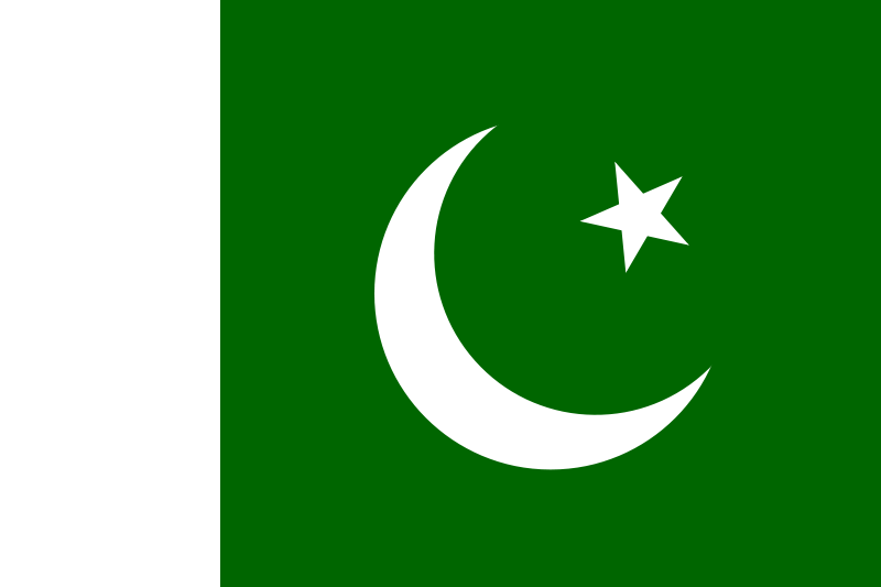
EXPLORING PAKISTAN
Situated on the crossroads of South Asia, the Middle East and Central Asia, Pakistan is a beautiful country with a unique history and cultural heritage. Pakistan was the site for one of the world's earliest human settlements: the great prehistoric Indus Valley Civilization, the crucible of ancient empires, religions and cultures. The land of Pakistan ranges from lofty mountains in the north, the Karakoram and the Himalayas, through dissected plateaus to the rich alluvial plains of the Punjab. Then follows the desolate barrenness of Baluchistan and the hot, dry deserts of Sindh blending into miles and miles of golden beaches of Makran coast.
Provinces of Pakistan
Pakistan has four Provinces and they are :
1) Punjab
2) Sindh
3) NWFP
4) Balochistan
Islamabad the capital of Pakistan is a Federal Capital Area
Punjab
Punjab, its name meaning 'Land of Five Rivers', is the richest, most fertile and most heavily populated province of Pakistan. (The five rivers referred to the Jhelum, Chenab, Ravi, Sutlej and Beas)
The best time to visit northern Punjab is in the spring, from February to April, and in the autumn, from September to November. Southern Punjab is extremely hot in summer, so Multan is at its best in winter, from November to February
Lahore
 |  |
Situated on the east bank of the Ravi River, Lahore is a very old city. Legend traces its origin to Loh, the son of Rama Chandra, the hero of the Ramayana, but history records that it began as a dependency of the 8th century AD Hindu ruler, Lalitiditya. In the early 11th century it came under Muslim rule and evolved as a centre of Islamic culture and learning as well as trade and commerce. In the 13th century it was depopulated and razed to the ground by the Tartar-Mongol hordes of Genghis Khan. Lahore was a cultural and intellectual centre during both the Mughal and British eras, but it is the diversity and contrast of the different sections of the city which make Lahore interesting.
Badshahi Mosque
 |
The Imperial or the Badshahi Mosque is across the courtyard from Alamgiri Gate of the Lahore Fort. The Mosque, which is made up entirely of red sand-stone, was built by Emperor Aurangzeb, the last of the great Mughals, in a record time of two and-a-half years.
Minar-e-Pakistan
 |
Minar-e-Pakistan is a new landmark in Lahore and stands in the Iqbal Park to commemorate the date when a resolution was passed there in 1940 demanding the creation of separate homeland for the Muslims of South Asian sub-continent. The Minar is a blend of Mughal and modern architecture. The Minar is about 60 meters tall.
Shalimar Gardens
 |
Three miles east of Lahore are the famous Shalimar Gardens laid out by the Mughal Emperor Shah Jehan in 1642 AD. The Gardens are spread out in typical Mughal style and are surrounded by high walls with watch-towers at the four corners. Originally, the gardens were spread over seven ascending terraces, but only three remain now which cover an area of about 42 acres. The brick-work of the floors of the three terraces have been repaired according to their original designs which differ on all three terraces. There is a marble pavilion underneath with water flows and cascades down over a carved, marble slab creating a waterfall effect. Across the waterfall is a marble throne. At the end of the second terrace is a beautiful structure called Sawan Bhadon, a sunken tank niches on its three sides. Water cascades down from it in sheets in front of the niches, producing the sound of falling rain.
Pakistan 's principled position on Jammu and Kashmir is based on the UN Security Council Resolutions, which provide that the final disposition of Jammu and Kashmir will be made in accordance with the will of the people. Pakistan is committed to this position until the three parties to the dispute, Pakistan , India and the people of Jammu and Kashmir arrive at some mutually acceptable final settlement.
Pakistan has always emphasized the necessity of a meaningful, constructive and result oriented dialogue to resolve the Jammu and Kashmir dispute. Pakistan maintains that rigidity and aggression must give way to accommodation and flexibility.
In their struggle for self-determination, the Kashmiri people have undergone untold sufferings and hardship over the years. Pakistan believes that the Kashmiri people must be associated with the Pakistan-India dialogue process for arriving at a sustainable solution. Their legitimate aspirations cannot be ignored and must be accommodated in any just and durable solution.
HISTORICAL BACKGROUND
The Kashmir dispute between Pakistan and India dates back to the partition of British India into two independent states in August 1947. At the time, the princely states under British suzerainty but not directly ruled by the British Government opted for joining either Pakistan or India taking into account their contiguity to one or the other country and the wishes of their people.
In the case of Jammu and Kashmir , the ruler was Hindu while the population was overwhelmingly Muslim and wanted to join Pakistan . India consistently pressurized the Hindu ruler to accede to India . Apprehending that the Hindu ruler was likely to succumb to Indian pressure, the people of Jammu and Kashmir rose against him, forcing him to flee from Srinagar . On 24 th October 1947 they formed their own government. On 27 th October, the Government of India announced that the Hindu ruler had acceded to India . This claim was made on the basis of a fraudulent instrument of accession. India sent its forces into the State and occupied a large part of Jammu and Kashmir . Indian leaders, including Prime Minister Jawaharlal Nehru and Viceroy Lord Mountbatten, solemnly declared that the people of the State would decide the final status of Jammu and Kashmir . For over half a century, the Kashmir dispute has bedevilled relations between Pakistan and India . Several efforts, for resolution of the issue, both at multilateral and bilateral levels have failed to show any meaningful result.
India took the matter to the UN Security Council in 1948. The UN Security Council through its Security Council Resolutions No. 47 (1948), 51 (1948), 80 (1950) and the United Commission for India and Pakistan resolutions of 13 August 1948 and 5 January 1949 declared that accession of Jammu & Kashmir to India or Pakistan should be decided through the democratic method of a free and impartial plebiscite. These UN resolutions were accepted by both India and Pakistan . Prime Minister Nehru declared before the Indian Parliament that India was committed to holding a free and fair plebiscite in Kashmir . However, India reneged on its commitment to hold plebiscite on the pretext of this stance.
In 1951 India projected the rigged assembly elections in the Indian occupied Kashmir as a substitute to the UN sponsored plebiscite. However, t he UN Security Council Resolution No.91 (1951) denied the authority of the Constituent Assembly to decide about the future of the state and reminded the parties that the final disposition of the state of Jammu & Kashmir is to be made in accordance with the will of the people of Kashmir. The UN Resolution No.122 (1957) reaffirmed the earlier resolution of 1951 stating that the elections could not be held as substitute to the plebiscite.
India now claims that Kashmir is an integral part of India. This contention is misleading and incorrect because of the following reasons:
• The disputed character of Jammu & Kashmir has been recognized by the UN, accepted by both India and Pakistan and endorsed by the international community.
• The Line of Control in the disputed area of Jammu & Kashmir is not an international boundary and recognized as such by India.
• There is complete alienation in the Indian occupied Kashmir (IoK) against the Indian rule.
• Pakistan and India in the Joint Statement of 6 January 2004 are committed to seeking a final settlement of the Jammu & Kashmir dispute.
Outside the UN, direct negotiations between Pakistan and India were held from the very inception of the dispute in 1947. Several rounds of negotiations held during the past five decades have not resulted in any meaningful or substantive progress as India adamantly maintained that the status quo cannot be changed.
Over half a century, the people of Kashmir are awaiting the exercise of their right to self-determination. Non-implementation of the Security Council resolutions coupled with the massive violations of the human rights by the Indian Security Forces has compelled the people of IoK to resist Indian occupation.
In 1989, the people of Jammu and Kashmir, inspired by similar movements for freedom in other parts of the world, rose against the Indian occupation. India sought to suppress their movement with massive use of force, killing hundreds of innocent men, women and children.
Since 1989, more than 90,000 Kashmiri people have been killed. There are over 700,000 Indian troops in IOK. There have been numerous cases of human rights violations. Inspite of the brutal repression of the Indian Security forces, the peaceful struggle of the Kashmiri people continues undaunted.
In fact Indian state terrorism in Occupied Kashmir has become even more pronounced in the post September 11 phase. India has tried to use the global sentiment following the September 11 events to paint the Kashmiri freedom struggle as terrorism and its own repression of that indigenous freedom struggle as a means to fight against terrorism.
In an attempt to malign Pakistan and the Kashmiri freedom movement, India has stepped up its propaganda of cross LOC infiltration from Pakistan and our involvement in so-called cross border terrorism. These allegations are nothing but a ploy to shift focus from the massive violation of human rights being perpetrated by the Indian Security Forces in IOK. While making such baseless allegations, India refuses to allow a neutral mechanism to investigate these charges.
Pakistan has all along emphasized the need to further strengthen and enhance the monitoring of the LoC by the United Nations Military Observer Group in India and Pakistan (UNMOGIP). UNMOGIP is the UN's oldest peace-keeping operation.
THE COMPOSITE DIALOGUE PROCESS
After a long period of heightened tension and stalled dialogue, the Prime Minister of India, Mr. Atal Behari Vajpayee visited Islamabad on 3 – 6 January 2004 to attend the 12 th SAARC Summit. In a joint statement issued on 6 January, 2004, the President of Pakistan and the Prime Minister of India agreed to commence the process of the Composite Dialogue. The Joint Statement also committed the two countries to find a permanent solution to the Jammu & Kashmir dispute acceptable to all parties.
The Composite Dialogue that commenced in February 2004 between Pakistan and India is a means to achieve a just settlement of the Jammu and Kashmir dispute in accordance with the aspirations of the Kashmiri people. Earlier, Pakistan had set the stage for the resumption of the dialogue process by announcing a vital CBM in the shape of declaration of a unilateral cease-fire across the LOC in November 2003.
During the past 2 and half years, while the Composite Dialogue has been in process, Pakistan has tabled certain concrete proposals for working towards a final settlement of the Jammu and Kashmir dispute. The four-point formula presented by the President offers the best mechanism to break the impasse. The four-point formula envisages that:
• Official talks commence,
• Centrality of the Jammu and Kashmir dispute is acknowledged,
• Any proposal unacceptable to any party or Kashmiris is taken off the table and,
• Best solution acceptable to the parties and the Kashmiris is taken up,
All Kashmir related proposals demonstrate Pakistan's sincere desire and reflect flexibility and readiness to take bold initiatives. Given sincerity, flexibility and courage on both sides, it should be possible to move forward towards a just settlement.
The Pakistani side has urged India to move forward together with Pakistan in a search for a final settlement that is acceptable to the Kashmiri people. We have also reiterated in unequivocal terms that the Jammu and Kashmir issue is the core issue, which cannot be sidelined and put on the backburner.
In addition to the Composite Dialogue, the two sides have agreed on a number of Kashmir-related Confidence Building Measures (CBMs), including intra-Kashmir bus and truck services, opening of crossing points on the Line of Control (LOC), meeting points for divided Kashmiri families on the LOC and greater interaction among Kashmiri leadership on both sides of the LOC. These CBMs have improved the political atmosphere in the region, which together with conducive international environment, offer a unique opportunity for both Pakistan and India to resolve the Kashmir dispute. While the CBMs have their importance, progress towards a settlement alone will raise hopes, reinforce confidence in the peace process and discourage violence and militancy that has persisted since 1989 largely as Kashmiri reaction to human rights violations and heavy Indian military presence in IOK.
On 11 July 2006 India used the Mumbai blasts to postpone the Foreign Secretary level talks to review the 3 rd round of the Composite Dialogue. India blamed elements from Pakistan for their involvements in the blasts. The Indian decision to put on hold the Foreign Secretary level talks has been seen as a negative development by Pakistan and the international community. The Indian decision was also at variance with the Joint Statement issued on 18 April 2005 by the leaders of Pakistan and India that “terrorist acts would not be allowed to derail the peace process”. While Pakistan has condemned the terrorist attacks in the Mumbai at the highest level and has offered assistance in investigating the blasts, India continue to point fingers at Pakistan.
Progress towards a settlement should not be linked to sporadic terrorist incidents anywhere in Indian occupied Kashmir or India. This would only add to the frustration of the Kashmiris who continue to suffer heavy Indian military presence, human rights violations and harsh laws, such as J&K Public Safety Act and Armed Forces Special Prevention Act. These gross human rights violations have been documented by Amnesty International and Asia Watch.
President Musharraf has emphasized the need for “out of box thinking,” sincerity, flexibility and courage to address this dispute. He has stated that a solution of this dispute must be acceptable to Pakistan, India and most importantly, the people of Jammu and Kashmir.
Pakistan has never shied away from bilateral engagement with India of which the ongoing Composite Dialogue is a manifestation. We hope that the process of composite dialogue will lead to peaceful settlement of all bilateral issues, including Jammu & Kashmir, to the satisfaction of both sides. Only a constructive dialogue would promote progress towards the common objective of peace, security and economic development of our people and for future generations.